


Highlights
Highlights of the Gokyo Cho La Pass Trek
- Stunning Mountain Views: Witness breathtaking vistas of Everest, Lhotse, Nuptse, Makalu, and Cho Oyu from multiple vantage points.
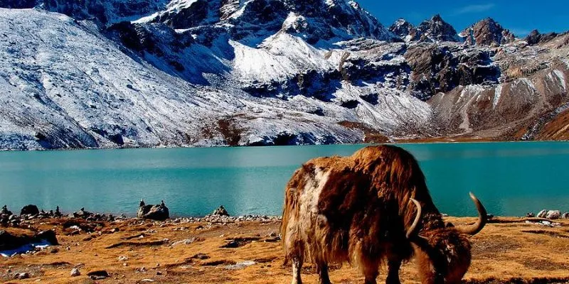
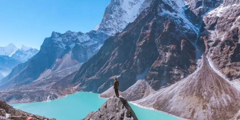
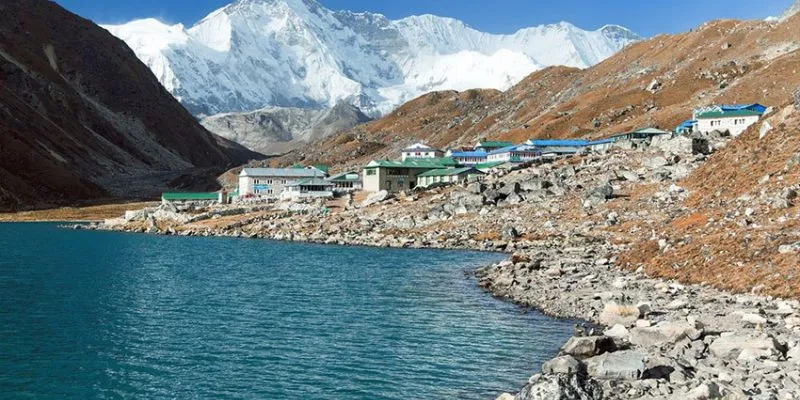
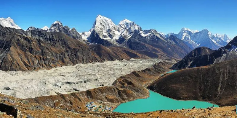
- Gokyo Lakes: Explore the turquoise glacial lakes of Gokyo, surrounded by towering peaks.
- Cho La Pass (5,420m): Experience the thrill of crossing one of the highest and most challenging passes in the Everest region.
- Gokyo Ri (5,357m): Hike to this iconic viewpoint for panoramic views of Everest and surrounding peaks.
- Everest Base Camp: Reach the base of the world's highest mountain and stand at the foot of Everest.
- Cultural Exploration: Discover Sherpa culture and traditions in villages like Namche Bazaar, Dole, and Thame.
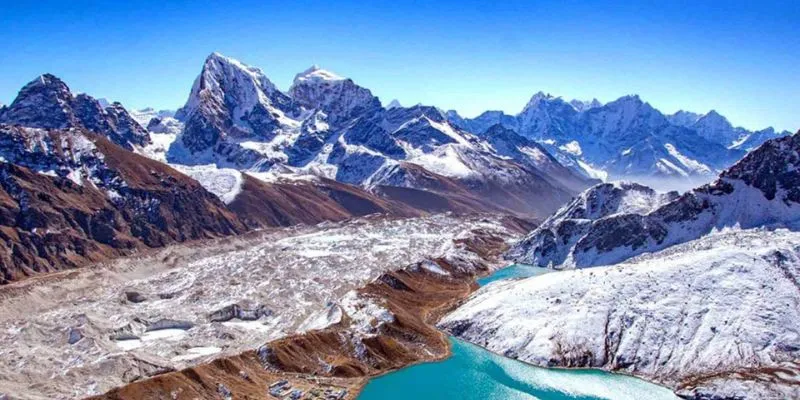
- Ngozumpa Glacier: Trek across Nepal's longest glacier for an unforgettable experience.
Overview
The Gokyo Cho La Pass Trek is one of the most scenic and rewarding trekking routes in Nepal’s Everest region. This adventure blends high-altitude trekking, glacial landscapes, and iconic Everest viewpoints into one unforgettable journey.
Starting in Kathmandu, you’ll fly to Lukla and begin trekking through lush valleys toward Namche Bazaar, the heart of the Khumbu region.
The journey then diverges from the classic route into the serene Gokyo Valley, where you’ll witness the stunning Gokyo Lakes. Crossing the dramatic Cho La Pass, you’ll rejoin the Everest Base Camp trail, culminating at Everest Base Camp.
This trek is ideal for those seeking a less crowded yet more diverse Everest trekking experience.
Why Choose This Tour?
The Gokyo Cho La Pass Trek Nepal offers more variety than the traditional Everest Base Camp trek.
You’ll experience:
- Fewer crowds and more tranquility
- Diverse landscapes: lakes, glaciers, and high passes
- Unique perspectives of Everest and surrounding peaks
- A rewarding challenge with incredible views
This trek is perfect for adventurers who want a complete Everest experience with added exploration.
Route / Destination Experience
Your journey begins with a scenic flight from Kathmandu to Lukla, followed by a gradual ascent through Phakding to Namche Bazaar.
After acclimatization, the trail branches toward Dole and Machhermo, entering the quieter Gokyo Valley. As you approach Gokyo, the landscape transforms into a dramatic alpine environment with glacial lakes and towering peaks.
After exploring Gokyo, the trek continues to Thagnak and crosses the challenging Cho La Pass, a highlight of the journey. From Dzongla, you reconnect with the classic Everest Base Camp trail, leading to Lobuche and Gorak Shep.
A visit to Everest Base Camp and surrounding glaciers completes the adventure before descending back through Pheriche, Namche, and Lukla.
Main Attraction / Key Experience
The defining highlight of this Gokyo Lakes and Cho La Pass Trek is the combination of serene lakes and high mountain adventure.
Key experiences include:
- Standing beside the pristine Gokyo Lakes
- Crossing the icy Cho La Pass
- Reaching Everest Base Camp
- Panoramic Himalayan views from Gokyo Ri
This unique combination makes it one of the best treks in Nepal.
Best Time to Visit
Spring (March to May)
- Ideal for clear mountain views and stable weather
Autumn (September to November)
- Best for high altitude trekking in Nepal
- Crisp air and excellent visibility
These seasons provide the safest and most enjoyable conditions for this trek.
Cost / Booking Information
This Gokyo Cho La Pass trekking package typically includes:
- Kathmandu–Lukla flights
- Trekking permits and fees
- Guide and porter services
- Teahouse accommodation
- Meals during trekking
Optional upgrades:
- Private guide
- Helicopter return from Gorak Shep
- Customized trekking extensions
- Early booking is recommended for peak seasons.
Important Travel Information
- Difficulty Level: Moderate to Challenging
- Maximum Altitude: 5,420m (Cho La Pass)
- Accommodation: Teahouses and mountain lodges
- Fitness Level: Good physical condition required
Travel Tips:
- Proper acclimatization is essential
- Carry warm, layered clothing
- Travel insurance with high-altitude coverage required
Conclusion
The Gokyo Cho La Pass Trek is the perfect blend of adventure, beauty, and solitude in the Everest region.
From the shimmering Gokyo Lakes to the thrilling Cho La Pass and iconic Everest Base Camp, this trek delivers an unforgettable Himalayan experience.
Book your Gokyo Cho La Pass Trek today and explore Everest from a whole new perspective.
Alternative Tours & Packages
- Luxury Everest & Gokyo Helicopter Trek – 5-Star Mountain Expedition
Embark on a premium trekking journey through the Everest and Gokyo regions, featuring scenic hikes, exclusive helicopter transfers, and upscale accommodations — designed for comfort and adventure in equal measure. - Ultimate Everest Adventure: Gokyo Lakes & Base Camp Trek
Take on one of Nepal’s most diverse treks, connecting the shimmering Gokyo Lakes with the dramatic Cho La Pass and the legendary Everest Base Camp, all while soaking in stunning Himalayan landscapes. - Everest & Gokyo Lake Helicopter Tour
Witness the majestic beauty of Everest and the crystal-clear Gokyo Lakes from above on this thrilling aerial tour — perfect for travelers seeking sweeping views in just one spectacular day.
Included and Excluded
- Arrival and departure transport by a private car, van, or bus.
- Three meals a day during the whole trek (breakfast, lunch, and dinner).
- The best possible accommodation during the whole trek.
- An experienced English-speaking trekking guide with his insurance.
- One porter with his insurance.
- Airfare for the flight from Kathmandu to Lukla and back to Kathmandu for the staff, clients, and guide.
- First Aid Kit in case of some small injuries.
- Three nights' accommodation in a 2-star hotel on a bed-and-breakfast basis in Kathmandu.
- Permits for trekking (conservation fees).
- TIMS card (Trekking Information Management System).
- Organizing Helicopter rescue in case of any emergency (Paid by your insurance company or Trekkers themself)
- All the required government fees and taxes.
- International airfare (Home country-Nepal-Home country).
- All the meals in Kathmandu (lunch and dinner).
- Your travel insurance.
- Sightseeing entrance fees in Kathmandu.
- Visa to Nepal.
- Any kind of drink or beverage.
- Tips for Guides and Porters.
- Personal expenses like hot showers, battery charges, telephones, etc.
Itinerary
- Upon landing at Kathmandu International Airport, please check for your "Name Plate" at the main gate.
- Our company representative will be there to pick you up and escort you to your hotel in a private vehicle.
- Assistance will be provided for a smooth hotel check-in process.
- If time permits, the representative will take you to our office for a brief trip overview; otherwise, you'll head directly to the hotel.
- Enjoy dinner and overnight stay at a hotel in Kathmandu.
- Take an early morning flight from Kathmandu to Lukla (30–40 min) or from Ramechaap (20 min).
- Begin your trek towards Phakding, descending to Tharo Koshi River (Kusum Kangru Khola).
- Cross the suspension bridge, ascend to Ghat, and continue to Phakding.
- Visit the Gompa in Phakding for your first mountain views.
- Dinner and overnight at a teahouse/guesthouse in Phakding after 3–4 hours of trekking.
- We'll begin the day by trekking along the Dudh Koshi River towards Zamphuti, where you'll enjoy stunning views of Thamserku peak.
- Next, we’ll climb to Chomoa, home to an agricultural project that offers a glimpse into the local farming lifestyle.
- From Chomoa, we ascend to Monjo (Altitude: 2,840m), where we officially enter Sagarmatha (Everest) National Park, established in 1976.
- The trek continues uphill with breathtaking mountain views as we approach Namche Bazaar.
- The trek today will take around 5–6 hours.
- Overnight stay at a hotel in Namche Bazaar (Altitude: 3,420m).
- Today, we'll take a rest day to acclimatize to the high altitude and prevent altitude sickness before continuing the trek.
- We can hike to the Everest View Hotel, offering stunning views of Mt. Everest, Ama Dablam, Thamserku, Lhotse, and other peaks.
- You can explore the Khumjung valley, visit Hillary School, and stop by Khunde Hospital before returning to Namche.
- Spend time in Namche Bazaar, socializing with the friendly Sherpa and Rai people.
- Dinner and overnight at a lodge or guesthouse in Namche Bazaar.
- The trail begins with a gradual ascent to Namche Bazaar, followed by an easy, level walk to Kyangjuma (Altitude: 3,550m).
- From Chor Camp at Namche, you'll enjoy breathtaking views of Mt. Everest (8,848m), Lhotse (8,516m), Nuptse (7,879m), Peak-38 (7,591m), Ama Dablam (6,856m), Taboche (6,495m), and many other peaks.
- The trail then ascends steeply for about an hour and a half to Mongla Danda (3,978m), where you can take a break and admire the stunning view of Mt. Ama Dablam.
- After passing Phortse Thanga, the trail climbs steeply through juniper and rhododendron forests to reach Dole (Altitude: 4,090m).
- Dinner and overnight stay at a teahouse in Dole after approximately 5–6 hours of trekking..
- The trail starts with a gradual ascent to Namche Bazaar, followed by an easy, level walk to Kyangjuma (Altitude: 3,550m).
- From Chor Camp in Namche, you'll be treated to breathtaking views of Mt. Everest (8,848m), Lhotse (8,516m), Nuptse (7,879m), Peak-38 (7,591m), Ama Dablam (6,856m), Taboche (6,495m), and several other peaks.
- Afterward, the trail ascends steeply for about an hour and a half to reach Mongla Danda (3,978m), where you can pause to enjoy a stunning view of Mt. Ama Dablam.
- Continuing from Phortse Thanga, the trail climbs steeply through juniper and rhododendron forests, leading to Dole (Altitude: 4,090m).
- You'll have dinner and stay overnight at a teahouse in Dole after approximately 5–6 hours of trekking.
- Today's route takes you from Machhermo to Gokyo, starting with an ascent up a ridge that offers an outstanding view of the valley leading to Kangtega and the Cho-Oyu mountain range (Altitude: 8,201m).
- Beyond the ridge, the valley opens up as the trail passes through Pangka (Altitude: 4,390m), descending to the riverbank before starting the climb to the Ngozumpa Glacier’s terminal moraine.
- After a steep ascent, you'll reach Longponga, the first small lake (Altitude: 4,650m), where a family of Brahmin ducks has lived for years.
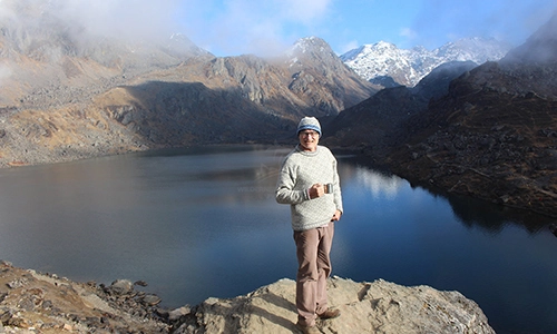
- Passing the second lake, Taujung (Altitude: 4,710m), the trail flattens as it leads to Gokyo Lake (Altitude: 4,750m).
- The trek will take around 4 hours today.
- Dinner and overnight stay at a teahouse in Gokyo
- We'll have a steep ascent to the top of Gokyo RI this morning (Alt. 5357m).
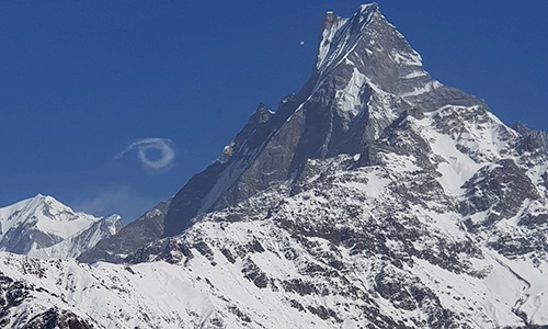
- From there, you can take in breathtaking views of the Gokyo valley, the enormous Ngozumpa Glacier, and a breathtaking panorama of the entire Khumbu mountain range, which includes such enormous peaks as Mt. Cho Oyu (Ht. 8201m), Mt. Everest (Ht. 8848m), Lhotse (Ht. 8516m), Nuptse (Ht. 7879m), Makalu (Ht. 8481m), and Cholaste (Ht. 7922m).
- We will then return to Gokyo (Alt. 4750m) after taking in the breathtaking views at Gokyo Ri.
- The trek from Gokyo Lake to Thakna will take us about 2-3 hours.
- Before taking about 45 minutes to descend along the valley to Thangana (Alt. 4700m), known as the base camp of Cho La Pass, the trail ascends and descends without difficulty through the glacier.
- You will enjoy lovely views of the mountains and other scenic features along the trail.
- The journey from Gokyo Lake to Thagnak is truly wonderful.
- Today’s trek will last approx 4-5 hrs.
- Stay for the night at the lodge in Thagnak.
- Today is one of the most challenging days, with a steep ascent and glacier crossing at Cho La Pass.
- The trail is steep and slippery with glazed rocks, requiring caution as we ascend through a narrow valley from Phedi.
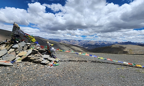
- As we climb, stunning views unfold, including a frozen lake and Cho La Pass (5,368m), adorned with prayer flags.
- You'll see famous peaks like Kyajo Ri, Teng Kang Poche, and Numbur along the way.
- After crossing the pass, we descend steeply to Dzongla (4,830m), passing crevasses and pine forests.
- Dinner and overnight at a teahouse in Dzongla after 7–8 hours of trekking.
- After passing through the Cho La Pass (Alt. 4910m), the distance between Dzongla and Lobuche is short and the trail is easy, so you can take your time and enjoy the trek .
- The trail gently descends and ascends before arriving at Lobuche.
- This trek offers spectacular views of Ama Dablam, Nuptse-Lhotse, Everest, Pumori, and Lobuche.
- Another memorable sight is the sunset over Nuptse from the small village of Lobuche, which is located close to the stream.
- Today’s trek will last approx 2-3 hrs.
- Spend the night at the teahouse in Lobuche.
- Today, we'll trek along the Khumbu Glacier until we arrive in Gorakshep. This is the closest village to Everest Base Camp.
- We’ll hike up to Everest Base Camp in the afternoon, where we can views a closest view of Everest.
- Today’s trek might last up to approx. 7-8 hrs.
- We will return to Gorak Shep for the night after ascending Everest Base Camp.
- Early in the morning, we'll hike up to Kala Patthar from Gorak Shep for a stunning view of the many Himalayas and a breath-taking sunrise.
- The Kala Patthar, which translates as "black rock," is the highest point we can hike in Nepal without converting our trekking permit into a climbing permit. The views of Nuptse and Changtse, as well as the up-close views of Everest can be seen from there, which is really extraordinary. The views are breathtaking whenever you hike up here, but sunset and sunrise are probably the best times to do so.
- The trail from Gorak Shep to Kala Patter begins with a steep ascent that lasts for about 30 minutes to get to the flat area where the 2009 cabinet meeting of the Nepal government regarding the issue of global warming was held. It was the first cabinet meeting ever held in such a high location.
- You will finally reach Kala Patthar after the challenging ascent with numerous bends, and it will take another 50 meters of rocky ascent to reach the summit of the main Kala Patthar (5545m).
- Today, you might have a great view of the sunrise over mountains like Mt. Everest (8848), Lhotse (8516m), Nuptse (7879m), Ama Dablam (6856m), Thamserku (6623m), Kangtega (6783m), Kusum Kangaru (6367m), Cholaste (6335m), Taboche peak (6495m), Lobuche peak (6090m), Lingtren.
- We will then trek down through Lobuche and Dughla as we head back to Gorak Shep for breakfast.
- You will cross the river a short distance from Dughla, which originates from the Khumbu icefall and Everest base camp .
- Then you will come across two trails, one of which leads to Dingboche on the left and Pheriche on the right. We will proceed through the left side, which is flat and can be descended smoothly to Dingboche through Dusa to a chorten at the Imja Khola's head.
- Finally, you'll arrive at Dingboche (4410m), where you will spend the night and have your delicious dinner after approx 7-8 hrs of trekking.
- After a delicious breakfast, we will enjoy another relaxing one-and-a-half-hour long walk down a zigzag trail bridge and across a suspension bridge over the Dudh Koshi River.
- When we finally arrive at Kyangjuma, we will ascend stone steps.
- After that, the trail is leveled until it reaches Namche, which takes about 3 hours.
- Spend the night at a lodge in Namche Bazaar after exhausting 7 hrs of trek.
- We set out for Lukla after taking in some stunning views of the mountains in Nepal's Everest region from Namche.
- We travel to Lukla using the same paved route along Jorsale, Monjo, and Phakding.
- The amazing mountainous region and lush forests will keep us motivated for the entire journey.
- Today’s trek will last approx 7-8 hrs.
- Spend the night in a guesthouse in Lukla tonight.
- Today, we'll walk to Tenzing Hillary Airport for your flight back to Kathmandu, or you can fly from Lukla to Ramechaap and then drive to Kathmandu.
- Please note that flights from Lukla typically operate in the morning due to unpredictable weather in the afternoon. If weather conditions delay your return to Kathmandu, we recommend adding an extra day to your itinerary.
- Enjoy a scenic and thrilling 25 to 30-minute flight back to Kathmandu, where you’ll be transferred to your hotel.
- After your long trek through the Himalayas, you'll have some free time to relax and catch your breath, or you can do some last-minute shopping.
- Dinner and overnight stay at a hotel in Kathmandu.
- On this final day, you will receive your trekking permits, TIMS card, and trekking appreciation card as souvenirs from your journey through the Himalayas.
- A representative from our company will drive you to the international airport before your scheduled flight.
- We would greatly appreciate any feedback regarding your Cho La Pass Trek experience or our company, as it helps us improve our services for future customers.
- Depart with wonderful memories of your Himalayan adventure.
- Have a safe flight, and we hope to see you again soon!
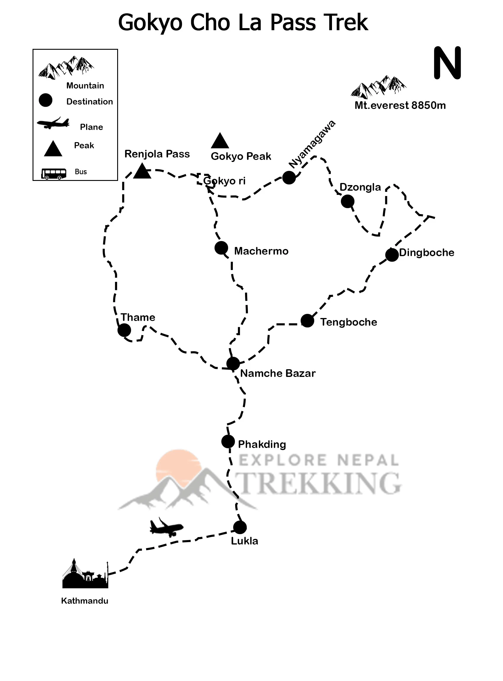
Route Map
Fixed Departure
Gokyo Cho La Pass Trek Availability
| # | Date | Cost | Status | Action |
|---|
FAQs
The best time to trek the Gokyo Cho La Pass is during spring (March-May) and autumn (October-November). These seasons offer mild temperatures, clear skies, and stable weather conditions, which are ideal for trekking and enjoying panoramic views of the Himalayas. While the winter months (December-February) are less crowded, they bring cold temperatures and snow, making the trek more challenging. The monsoon season (June-early September) is generally not recommended due to heavy rainfall and potential landslides.
The Gokyo Cho La Pass Trek is considered challenging due to its high altitude, steep ascents, and difficult terrain, especially when crossing the Cho La Pass at 5,417 meters. Trekkers should be in good physical condition and have some prior trekking experience, preferably at high altitudes. Acclimatization days are essential to reduce the risk of altitude sickness.
Trekkers need the following permits for the Gokyo Cho La Pass Trek: Sagarmatha National Park Entry Permit: Required to enter the Sagarmatha National Park, where most of the trek takes place. Trekkers' Information Management System (TIMS) Card: This permit is for safety and tracking of trekkers in the Everest region. These permits can be obtained in Kathmandu or Lukla, and it’s advisable to arrange them through a registered trekking agency.
The trek passes through diverse ecosystems, where you can encounter flora such as Birch, Juniper, Rhododendron, and Blue Pines. The region is also home to rare fauna, including the Red Panda, Musk Deer, Himalayan Monal, and Himalayan Tahr. The dense forests and high-altitude areas offer unique opportunities to observe these species in their natural habitat.
Customer Reviews & Rating
Showing Verified Reviews

Carlos Rivera - Madrid, Spain
(5.0)"Trekking the Gokyo Cho La Pass with Explore Nepal Trekking was a dream come true. The team was super helpful and treated us like family from the moment we landed. The trek had its tough moments, but the incredible lakes and mountain views made it totally worth it. I also loved learning about the Sherpa culture along the way. Great food, great people, great adventure!"
William S. O'Connor - 14 Merrion Square, Dublin 2, Ireland
(5.0)"The Gokyo Cho La Pass Trek was a truly spectacular and demanding high-altitude journey; the views from Gokyo Ri overlooking the stunning turquoise lakes and the massive glaciers were incredible. Crossing the Cho La Pass was challenging but rewarding, connecting us efficiently to the Everest Base Camp trail. Our experienced guide was essential for safe navigation and acclimatization, making this difficult, classic circuit a monumental success."


Michael Thompson - Vancouver, Canada
(5.0)"The Gokyo Cho La Pass Trek organized by Explore Nepal Trekking was beyond my expectations. The team was incredibly experienced and took care of every detail, from permits to accommodations. Crossing the Cho La Pass was challenging but immensely rewarding with spectacular panoramic views of the Himalayas. The guides were supportive and knowledgeable about the region’s geography and culture, making the trek both safe and enriching. Highly recommended for adventure seekers!"